UK Address and Postal Data FAQ: AddressBase, UPRN, PAF, and PSGA Explained
If you work with UK addresses, you've probably encountered terms like AddressBase, UPRN, PAF, and PSGA. These are fundamental components of the UK's address infrastructure, but they can be confusing.
This FAQ answers the most common questions about UK address and postal data systems. I hope it will help you as it helped me! 🙂
Looking for practical geocoding solutions? See our comparison of UK geocoding providers to find the best API for your needs.
Table of contents:
- What is a UPRN?
- What is a USRN?
- Why do UPRNs exist?
- How to check for a UPRN?
- What is AddressBase?
- What are the different AddressBase products?
- Can you give an example of AddressBase data?
- What is Royal Mail PAF?
- PAF vs AddressBase: What's the difference?
- Is AddressBase free and open data?
- Is Royal Mail PAF free and open data?
- What is the Public Sector Geospatial Agreement (PSGA)?
- What are the alternatives to AddressBase and PAF?
- How do UPRN, AddressBase, and PAF work together?
- Which should I use: AddressBase or PAF?
- Can I geocode UK addresses without AddressBase or PAF?
- Where can I learn more?
What is a UPRN?
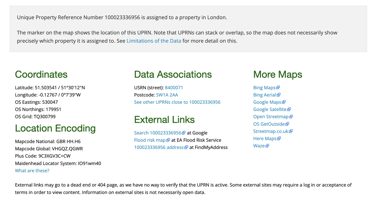
UPRN stands for Unique Property Reference Number. It's a unique 12-digit identifier assigned to every addressable location in Great Britain (England, Scotland, and Wales).
Each property has one UPRN that never changes, even if the address changes. These are simple 12-digit numbers (e.g., 100023336956) that cover residential homes, commercial buildings, sheds, garages, and even mailboxes. The system is managed by GeoPlace, a partnership between the Local Government Association and Ordnance Survey.

10008517798 (source)For example, 100023336956 is the UPRN for 10 Downing Street, London SW1A 2AA (the Prime Minister's residence). Even if the building's use or occupant changes, this 12-digit identifier remains constant, ensuring consistent identification across all government systems and databases.
This UPRN is associated to the 8400071 USRN (Unique Street Reference Number) for the street "Downing Street".
What is a USRN?
USRN stands for Unique Street Reference Number. It's a unique identifier assigned to every street in Great Britain, that can go up to 10 digits long.
Each street has one USRN that never changes, even if the street name changes. For example, 8400071 is the USRN for the street "Downing Street".
Why do UPRNs exist?
Using addresses as identifiers is problematic because:
- Addresses change: Streets get renamed, building numbers change
- Typos and variations: "High St", "High Street", "HIGH STREET" are all the same place
- Inconsistent formatting: Different systems store addresses differently
UPRNs solve this by providing a stable, unique identifier that connects all systems and databases.
For example, if 123 High Street, London is renamed to 123 King Avenue, London, the UPRN remains the same (e.g., 100023336956). This allows:
- Government records to stay linked
- Utility companies to maintain service history
- Emergency services to find the correct location
- Council tax records to remain accurate
How to check for a UPRN?
You can use the website uprn.uk to check for a UPRN.
100023336956 (source)What is AddressBase?
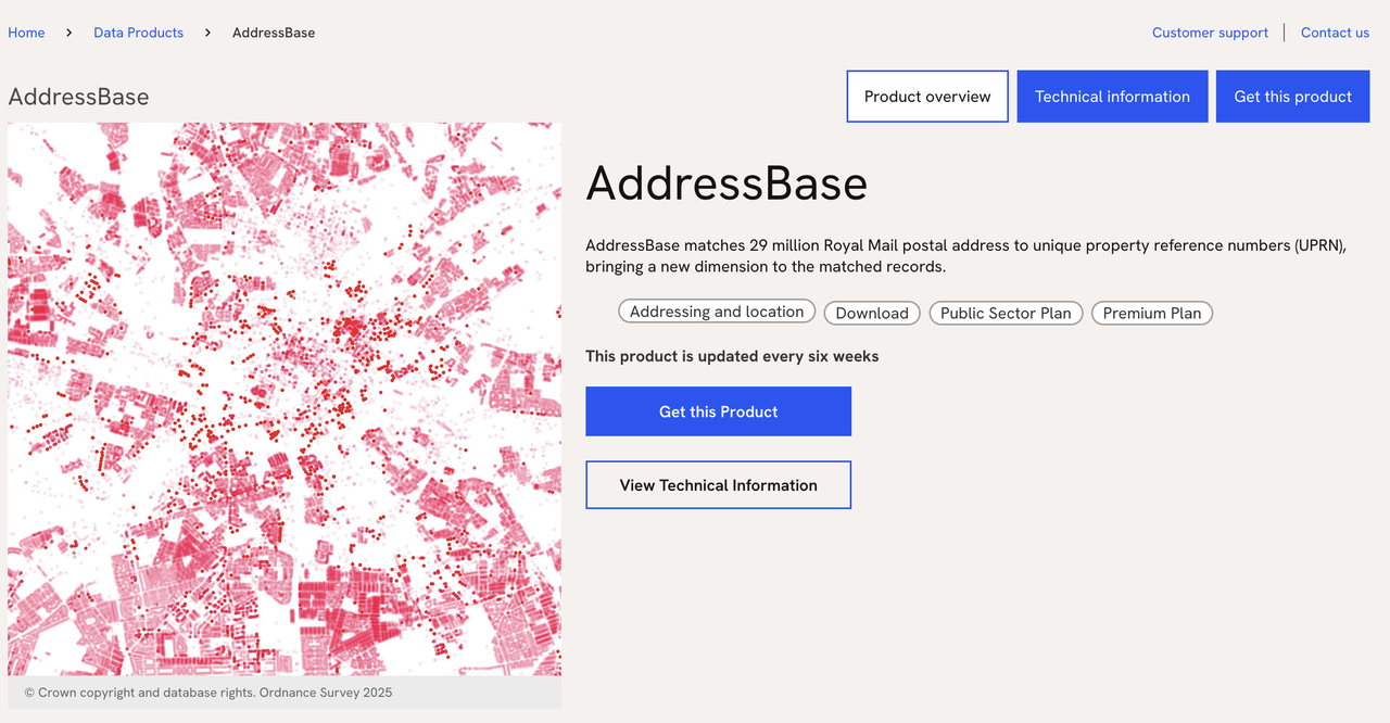
AddressBase is the most comprehensive and authoritative address database for Great Britain, maintained by Ordnance Survey.
It contains all UPRNs (every property's unique identifier), full addresses (building number/name, street, locality, town, postcode), geographic coordinates (latitude and longitude in British National Grid and WGS84), property classification (residential, commercial, etc.), local authority information (which council area the property belongs to), and multiple address formats (official address, alternative names, historical addresses).
What are the different AddressBase products?
Ordnance Survey offers three AddressBase products with varying levels of detail:
AddressBase Core provides basic address information with UPRNs and coordinates, suitable for simple address lookup and validation.
AddressBase Plus is an enhanced dataset with additional address details, multiple address formats (e.g., Welsh language variants), and property status information.
AddressBase Premium is the most comprehensive dataset, including full address history, alternative addresses (e.g., previous names), detailed metadata and relationships. It's best for complex applications requiring complete address intelligence.
Can you give an example of AddressBase data?
Here's a sample record from AddressBase Plus showing an address in Exeter, United Kingdom:
uprn: 10094201708
udprn: ""
parent_uprn: 55508903
sub_building: "FLAT 404"
building_name: "CLIFFORD HOUSE"
building_number: ""
dependent_thoroughfare: ""
thoroughfare: "STADIUM WAY"
double_dependent_locality: ""
dependent_locality: ""
post_town: "EXETER"
postcode: "EX4 6AX"
rpc: "S"
coordinates:
  x: 292839.08
  y: 093519.86
  latitude: 50.7313689
  longitude: -3.5197896
classification: 2
status: "E"
state: "I"
dates:
  start_date: 2018-07-03
  last_update: 2019-11-20
  entry_date: 2020-06-13
record_type: "R"
This record represents Flat 404, Clifford House, Stadium Way, Exeter EX4 6AX, with coordinates and metadata showing when the address was created and last updated.
What is Royal Mail PAF?
PAF stands for Postcode Address File. It's Royal Mail's database of all "delivery points" (addresses that receive mail) in the UK.
Managed by Royal Mail (the UK's postal service), PAF is delivery-focused and contains only addresses where mail is delivered. It's updated regularly to reflect new builds and address changes, covers all UK countries (England, Scotland, Wales, and Northern Ireland), and every address is linked to its postcode.
Each PAF record contains: building name/number, street name, locality, town, county, postcode, and a delivery point suffix (DPS) — a unique identifier within a postcode.
PAF vs AddressBase: What's the difference?
Let's take an example:
| Feature | Royal Mail PAF | AddressBase |
|---|---|---|
| Coverage | UK (including Northern Ireland) | Great Britain only (England, Scotland, Wales) |
| Focus | Mail delivery points | All addressable locations |
| Identifier | Postcode + DPS | UPRN |
| Includes | Only addresses receiving mail | All properties (including non-postal) |
| Managed by | Royal Mail | Ordnance Survey / GeoPlace |
| Coordinates | Not included (usually) | Included |
To illustrate: a property might be in PAF if it receives mail (e.g., 123 High Street, London SW1A 1AA), but in AddressBase whether or not it receives mail (e.g., a shed, garage, or temporary structure). Some properties (like construction sites or private roads) may have a UPRN but no PAF entry because Royal Mail doesn't deliver there.
Is AddressBase free and open data?
Short answer: Partially open — it depends on who you are and how you'll use it.
✅ Free access:
For UK public sector organizations, AddressBase is available through the Public Sector Geospatial Agreement (PSGA) (see below about this). This includes AddressBase Core and Plus, free to use for public sector purposes.
For others, some local authorities publish UPRN data as open data (not universal), and Ordnance Survey's OpenData products exist, but AddressBase is NOT included.
💰 Paid licenses required:
For commercial use, businesses need a paid license. Various developer license tiers are available based on usage volume. AddressBase Premium requires a paid license even for many public sector uses beyond basic PSGA coverage.
Important note: While UPRN itself is just a number, accessing the full database requires licensing. Using UPRNs in your application may require a license even if you obtain them elsewhere. Always check current terms on the Ordnance Survey website.
Is Royal Mail PAF free and open data?
No, PAF is not free or open data. Royal Mail licenses PAF commercially (see Royal Mail PAF pricing).
You can access PAF in three ways: directly from Royal Mail (various commercial licenses available, with pricing based on usage and application type, offering the full dataset or subsets for specific regions), through licensed resellers (many address validation and geocoding providers like Loqate, Postcode Anywhere, and Ideal Postcodes license PAF, allowing you to access it indirectly through their APIs), or for public sector (some limited access via PSGA, often supplemented with AddressBase).
Check out our comparison of UK geocoding providers to find the best API for your needs.
Royal Mail is a commercial company, and PAF is valuable intellectual property. Maintaining and updating the database requires significant resources, funded through licensing fees.
What is the Public Sector Geospatial Agreement (PSGA)?
The PSGA is a UK government initiative that provides free access to Ordnance Survey data for public sector organizations.
Who qualifies? UK public sector organizations, including central government departments, local councils and authorities, NHS organizations, police and fire services, educational institutions (schools, universities), and other public bodies.
What data is included? The PSGA provides access to AddressBase Core (free), AddressBase Plus (free), AddressBase Premium (limited access, may require additional licenses), OS MasterMap and other Ordnance Survey datasets, plus API access for online services.
What are the terms? The data is free to use for public sector business but cannot be shared with commercial third parties, cannot be resold or used for purely commercial purposes, and must be used for public sector functions.
How to access PSGA data: Check if your organization qualifies, register on the Ordnance Survey website, download data or access APIs, and use in compliance with PSGA terms.
What are the alternatives to AddressBase and PAF?
If you need free or open UK address data, consider these alternatives:
OpenAddresses UK is a crowdsourced, open-source address database with good coverage in many areas (though not complete), available under open data (public domain) license at openaddresses.io.
OpenStreetMap (OSM) offers community-maintained map data with UK addresses. Coverage varies by area (excellent in cities, patchy in rural areas), licensed under ODbL (Open Database License), accessible at openstreetmap.org.
ONS Postcode Directory (ONSPD) from the Office for National Statistics provides all UK postcodes with geographic info under the Open Government License at ONS Geoportal. Note: it contains postcodes and coordinates, not full addresses.
Local Authority open data: Some councils publish their address data (coverage varies widely by council), usually under the Open Government License. Check individual council open data portals.
Good to know: AddressBase and PAF are more complete and accurate, commercial data is updated more frequently, licensed data comes with support while open data is "as-is", and commercial licenses are clear while open data usage can be complex.
How do UPRN, AddressBase, and PAF work together?
In short, they complement each other in the UK address ecosystem.
Here's an example workflow: imagine a utility company needs to manage customer accounts. A customer signs up with address "10 Downing Street, London SW1A 2AA". The system looks up the address in AddressBase, gets UPRN 10008517798 and coordinates 51.5034, -0.1276, validates the postcode using PAF to confirm it's a mail delivery point, stores the UPRN as the primary identifier, and links all services to this UPRN (billing, service calls, maintenance history).
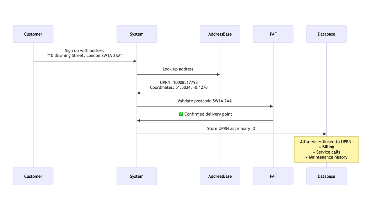
The benefits are clear: if the address changes, the UPRN stays the same; coordinates enable field service routing; the postcode confirms mail delivery is possible; and there are no duplicate customer records.
Which should I use: AddressBase or PAF?
It depends on your use case:
Use PAF if you need postcode validation, mail delivery confirmation, address formatting for postal services, Northern Ireland addresses, or simple address lookup by postcode.
Use AddressBase if you need UPRNs for data linking, geographic coordinates, all addressable locations (not just postal), property classification, local authority boundaries, or historical address data.
Use both if you need complete address intelligence, geocoding with postal validation, maximum coverage and accuracy, or integration with multiple systems.
Many organizations use both: AddressBase for the authoritative address register and UPRNs, and PAF for postal validation and formatting.
Can I geocode UK addresses without AddressBase or PAF?
Yes! You have several options:
Global geocoding providers include Google Maps Geocoding API (excellent for UK addresses), HERE Geocoding (good UK coverage), Mapbox Geocoding (uses OpenStreetMap + proprietary data), and TomTom Geocoding (commercial-grade accuracy). These services have their own address databases, often incorporating multiple sources.
UK-specific geocoding services include Ideal Postcodes (uses OS data, licensed), Loqate (uses PAF and other data), and Postcode Anywhere (UK-focused address validation).
Open-source geocoding options include Nominatim (OpenStreetMap geocoder, free and open-source) and Pelias (open-source geocoder that can use OpenAddresses).
Learn more in our comparison of UK geocoding providers: Best Geocoding Providers for the United Kingdom.
Where can I learn more?
Official sources:
- Ordnance Survey: ordnancesurvey.co.uk
- GeoPlace (UPRN): geoplace.co.uk
- Royal Mail PAF: royalmail.com/business/services/marketing/data-optimisation/paf
- PSGA Information: ordnancesurvey.co.uk/psga
Related articles:
- How geocoding works: A simple guide
- UK Country Analysis — Geocoding performance in the UK
Need help with UK addresses? Coordable can help you geocode, validate, and manage UK addresses with high accuracy, supporting multiple providers and data sources.