US Census + Google Maps: How to cut geocoding costs by 90% for US addresses
The setup
We wanted to test the effectiveness of a cascading geocoding strategy for US addresses. We took 1,000 real US addresses (a mix of residential and business addresses, of variable quality but overall correct) and ran three geocoding tests.
Here is the summary of the results:
| Test | Provider(s) | Addresses resolved | Cost per 1,000 |
|---|---|---|---|
| 1 | US Census only | 91.9% | $0.00 |
| 2 | Google Maps only | 92.6% | $5.00 |
| 3 | US Census → Google Maps (cascade) | 97.3% | $0.41 |
The cascade delivers 97.3% addresses found at $0.41, compared to $5.00 for Google Maps alone. That is a 90% cost reduction with a +5.4 percentage point improvement in addresses resolved. Amazing right?
Read on to see how each test was run and what the results look like.
Table of contents:
Test 1: US Census Geocoder
What is the US Census Geocoder?
The US Census Geocoder is a public and free API provided by the US federal government. It is not open source (the underlying software and data are maintained by the Census Bureau), but it is freely accessible, requires no API key, and has no published usage limits or cost.
It is built on TIGER/Line data, the official US address dataset. Results are interpolated on the street rather than placed at the exact building location (no rooftop precision). For most use cases (delivery routing, territory analysis, customer mapping), street-level interpolation is entirely sufficient.
The output data is in the public domain, with no licensing restrictions on how you store or use the coordinates.
Important limitation: US Census only understands structured street addresses. It cannot geocode points of interest, business names, or company names. If your dataset contains entries like "Starbucks, Chicago" or "Boeing headquarters", US Census will return nothing for those rows. In that case, the 90% cost reduction figure will not hold: a commercial provider will need to handle a much larger share of your requests. This strategy works best for datasets of clean street addresses ; see below for a solution.
Results
- Accuracy: 91.9% (919 out of 1,000 addresses resolved)
- Cost: $0.00
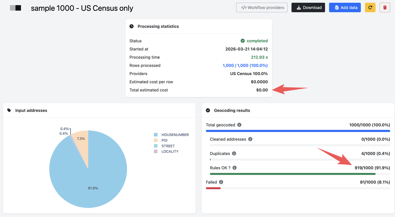
91.9% is a strong result for a free API. The 8.1% of unresolved addresses are typically due to non-standard formatting, missing components, or addresses that simply do not appear in the TIGER/Line dataset.
Test 2: Google Maps Geocoding API
What is Google Maps Geocoding?
Google Maps is one of the most widely used geocoding providers. At $5.00 per 1,000 addresses (after the free quota), it is also one of the most expensive.
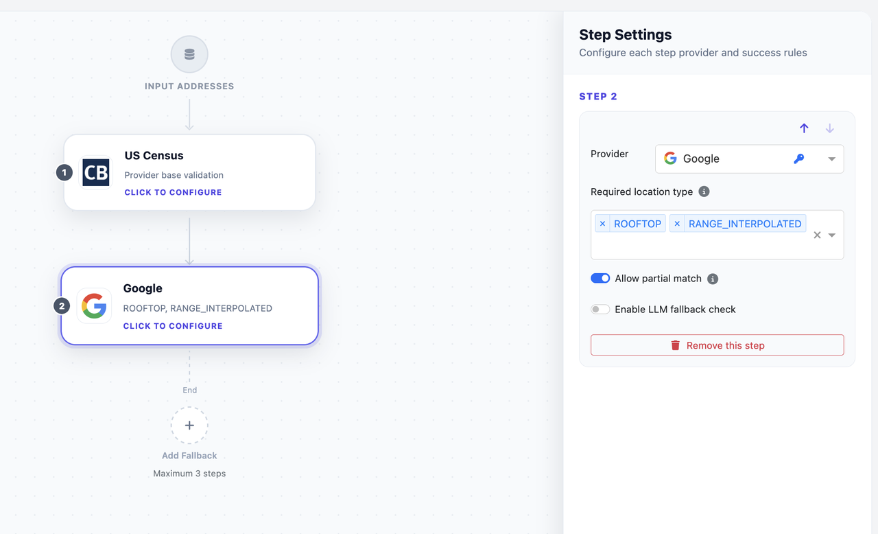
It returns different precision levels: ROOFTOP for exact building locations, and RANGE_INTERPOLATED for street-level interpolation. For a fair comparison with US Census, which only returns street-level results, we accept both ROOFTOP and RANGE_INTERPOLATED in this test.
Licensing note: Google Maps results come with significant restrictions beyond the price. Google's Terms of Service do not allow you to store geocoded coordinates long-term or use them outside of a Google Maps display context. If you need to build a database of geocoded addresses, use the results in a non-Google mapping tool, or export coordinates for analysis, you may be violating Google's terms. This is an important constraint to factor in before committing to Google as your primary geocoding provider.
Note: Google free quota is excluded from these cost figures, as its effective value depends on overall usage across all Google Maps products. The $5.00 figure reflects the standard pay-as-you-go rate.
Results
- Accuracy: 92.6% (926 out of 1,000 addresses resolved)
- Cost: $5.00
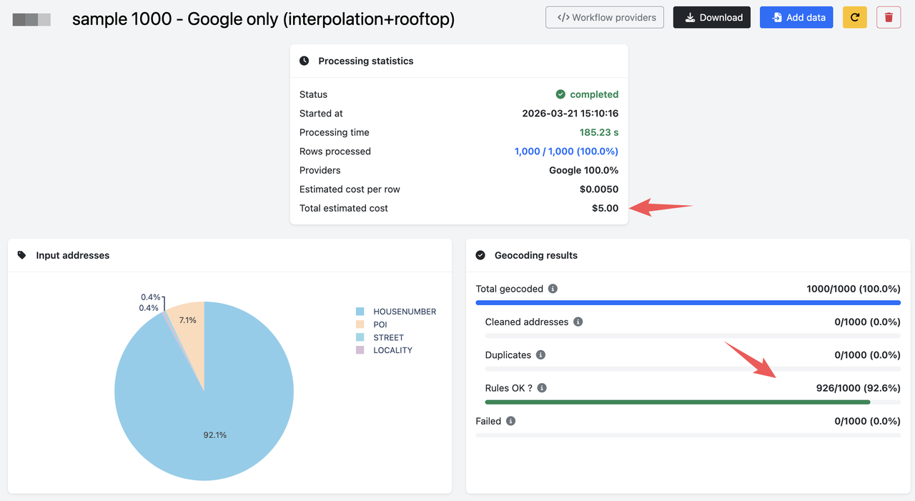
Google Maps edges out US Census by 0.7 percentage points (92.6% vs 91.9%), but at a cost of $5.00 per 1,000 addresses vs $0. For this dataset, paying for Google Maps buys very little extra accuracy on its own.
Test 3: US Census + Google Maps (cascade)
How the cascade works
The cascading strategy is straightforward:
- Send every address to US Census first. If US Census returns a valid result, use it. Cost: $0.
- For addresses that US Census could not resolve, send them to Google Maps. Cost: $5.00 per 1,000 for this subset only.
In our test, approximately 90% of addresses were resolved by US Census (free), and only ~8% required Google Maps, at a total cost of $0.41. The remaining ~2.7% were not resolved by either provider.
This is why the cost drops so dramatically: instead of paying $5.00 for every address, you only pay Google's rate for the small fraction that US Census could not handle.
Results
- Accuracy: 97.3% (973 out of 1,000 addresses resolved)
- Cost: $0.41
- Provider split: ~90% resolved by US Census · ~8% resolved by Google Maps · ~2.7% unresolved
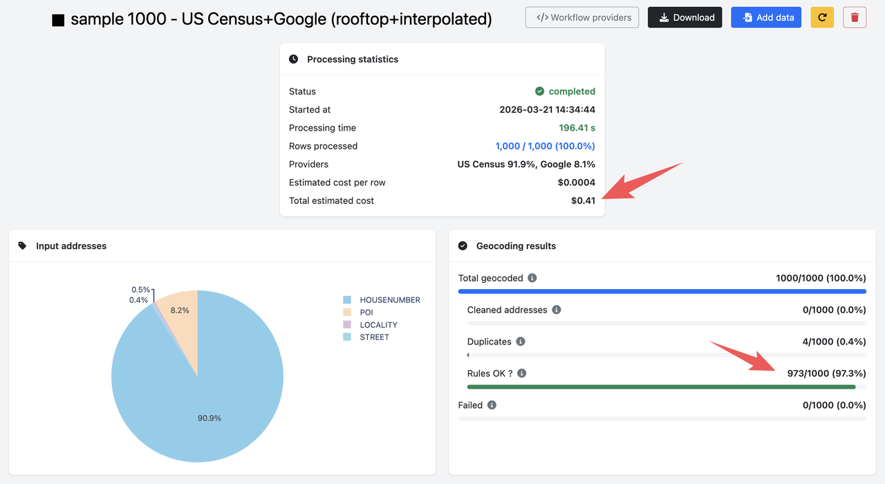
The cascade delivers a +5.4 percentage point improvement over either provider alone, at 8% of the cost of Google Maps. The key insight is that US Census and Google Maps fail on different addresses. Addresses that US Census cannot parse or match are often resolved by Google's more robust parsing engine, and vice versa.
Set up cascading geocoding with Coordable
Going further: adding a third provider
This two-provider cascade already delivers strong results, but you can push accuracy even higher by adding a third provider.
For example, adding HERE as a second fallback (after Google Maps) would catch some of the 2.7% of addresses that neither US Census nor Google resolved. HERE has strong US address coverage and is significantly cheaper than Google Maps at $0.83 per 1,000 addresses. A three-provider cascade (US Census → Google Maps → HERE) would likely push accuracy above 97.3% while keeping the overall cost low, since HERE would only handle the tiny fraction of addresses that both previous providers missed.
We ran a similar experiment with French addresses using the BAN API (the French government geocoder), Google Maps, and HERE, and achieved 97.7% accuracy at $1.62 per 1,000, a 67% cost reduction compared to Google alone. The principle is identical: route easy addresses through the cheapest provider, and reserve expensive providers for the hard cases. See How to reduce geocoding costs by 67% for the full breakdown.
Conclusion
For US address geocoding, the US Census Geocoder is a powerful and underused tool. It is free, requires no API key, and handles the vast majority of clean street addresses correctly. Pairing it with Google Maps as a fallback gives you the best of both worlds: near-complete coverage at a fraction of the cost.
| Test | Provider(s) | Found | Cost per 1,000 |
|---|---|---|---|
| 1 | US Census only | 91.9% | $0.00 |
| 2 | Google Maps only | 92.6% | $5.00 |
| 3 | US Census → Google Maps (cascade) | 97.3% | $0.41 |
The key caveat: this strategy works for street address datasets. If your data contains business names, POIs, or unstructured inputs, US Census will not help and you will need a commercial provider for a larger share of requests.
However, it would have been possible to plug a low-cost provider to handle the remaining addresses as well : HERE, Nominatim (OSM), OpenCage, etc.
If you want to implement this cascade without writing custom code, Coordable lets you configure multi-provider workflows with quality rules at each step, so only good results pass through.
Try cascading geocoding with Coordable
Where to go from here
- See how the same cascading approach cuts costs by 67% for French addresses: How to reduce geocoding costs by 67%
- Compare geocoding prices across all major providers: Geocoding prices in 2026
- Learn more about Google Maps Geocoding: Google Maps Geocoding API